Current mood: hopeful
First, bring up this link in a separate tab or window. It shows a map of the area near my house (marked as "me"), with several nearby residences also marked. There are only two bus routes in this area that matter, one which travels Perry Hwy, the 11C, and one which travels McKnight Road, the 12A. (For simplicity, I am ignoring several naming variants and other routes which cross the edges of this view, at least for now.)
What brought this about was talking with a man yesterday whom I had previously not met. He mentioned that he used the system occasionally, but only after driving some distance, since it was so difficult to use the system from nearby his house. We exchanged business cards, and I was amazed to find out that he lives less than a half mile away (marked as "WS"), and would board the exact same 11C that I do, only one or two stops north of me.
How was it, then, that if I can find the system so indispensable, he cannot use it at all? Well, take a look at where I am, and where he is. I need only walk a mere tenth of a mile west on Perrymont Road, where I can cross four-lane Perry Highway at a "walk" light. He, by contrast, must walk a half mile on narrow, unlit, sidewalk-less suburban residential side streets. This area is also very hilly. While I am part mountain goat, quite capable of dealing with mud, snow and ice, I can easily see why this would be hard or distasteful enough to dissuade most people from finding transit a desirable "Plan A".
Also by contrast, consider my neighbor "ZZ", who lives even closer to his 11C stop than I am to mine. One thing ZZ and WS have in common, though, is that they must cross Perry Hwy without a traffic light. It's tough. Dozens of cars a minute whiz by. ZZ puts up with it, possibly because he is so close.
Now also consider the people living west of WS, shown as JB and DJ. JB is a full mile off the main drag, DJ almost 1.2 miles. These neighborhoods are classic examples of suburban sprawl, with tract after tract of land developed from either forest or farmland. The hundreds of people back in these developments, if they were to use transit, would travel to those same three bus stops along Perry Highway. However, this is not going to happen, since virtually nobody back there will walk that far, nor is there anyplace to legally park a car or even a bicycle closer to these stops. Also because of the low density, there is no chance at all to get a bus to circulate these neighborhoods. Indeed, the 11C itself has been cut back severely due largely to ridership losses. [Update, 2011: The Perry Highway service has been eliminated entirely due to transit funding cuts.]
Rider KK, on the other hand, at top center of the map, used to drive her car to the parking lot of a large office building by Perry & Perrymont. She had permission to do this, but apparently no longer does, despite some 80 of the lot's 135 parking spaces never being in use on any given day. This was not her decision. As a result, one more car has to chase into Downtown every day, or fight for the pitifully few legal park-and-ride spaces that do exist. Four other large lots along Perry similarly sit empty or nearly so, some with nasty "commuters stay out" signs prominently posted, while, conversely, the community college (in north-center of map, unmarked) has constructed oceans of asphalt to handle its commuter load. Can't some of those students get there by bus? A couple do, but not the hundreds who could of the thousands who drive.
Now consider the difference in difficulty faced between two almost neighbors, JO and JD, who live barely 100 yards apart in distance, but worlds apart in difficulty in using transit. JO needs only walk a quarter mile up to Perry Highway, and for the inbound side, can walk another few feet to cross at the Perrymont traffic light. By contrast, JD cannot do that. She would have to hike a mile to get out to McKnight Road. For her, there is no reasonable method to get to Perry Hwy.
MK (on the eastern side of the map), by contrast, also has to hike out some distance, about a half mile, but this is a bit more do-able, as much of his hike involves wide shoulders and connected parking lots. He also has another option, a third route, which travels Peebles Road. He prefers the McKnight bus, though, because it is a faster trip home, even with the walk, and there is better rush-hour service. I, too, can use the McKnight buses, since it is a straight 3/4 mile hike east on Perrymont, and the comparatively large amount of service makes up for the plain-nutso difficulty in walking along Perrymont. But even close-by ZZ would find the McKnight options prohibitively difficult. Though I might consider them close enough, those buses are a world away for him.
All of this illustrates, I hope simply, how different an experience can be had for several people within a very narrow geographic area. For all, there is no sidewalk anywhere to be found, and what lighting exists is bad. It would be better to remove it.
Welcome to riding transit in the suburbs!
The solution to all this -- why I want someone to hire me -- is to develop a scheme to resolve some of this difficulty. Much of it would be low-tech, low-cost stuff like improving shoulders (e.g., put down some gravel), trimming branches, and improving lighting. Some of it would be getting parking-lot owners to allow some limited commuter parking, especially on the little-used fringes.
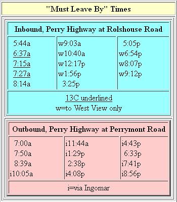
The big change, though, involves some technology. Point-specific timetables that vary from house to house that would tell people when to leave the house to catch a bus (example), or how to make connections to get Downtown, or get back, would ease greatly the difficulty in figuring out how to catch what service does exist.
I figure this would cost someone $100,000 to $200,000 -- tiddlywinks when compared to what transportation projects cost. A hundred grand might buy a single traffic light. A half-million might add a right-turn lane at an intersection. A bridge widening is going to run into seven digits. Re-timing all the traffic lights on McKnight Road a few years ago cost five to seven million. Rebuilding the Parkway East is getting into eight digits. The MFSoB (Mon-Fayette/Southern Beltway) project will cost five billion.
On the other hand, pay me a decent salary for a year, and be willing to implement whatever I come up with, and then we won't have to build as much. It may cost a few hundred thousand more to put my ideas in place, but that's still insanely cheap compared to constantly building out the road system. However it gets paid for, that's still all tax money.
Just in Pittsburgh, projects to improve the highway system each year run well into the hundreds of millions of dollars. It costs roughly $300 million to run the transit system for a year, too, over half of which comes from tax dollars in one form or another. The difference between its needs and the availability of that money ran to almost $80 million this year.
Getting 50,000 more people a year to buy a bus pass, by contrast, would put dozens of millions of dollars into the system, and take tens of thousands of cars off the road each day. Do you see where I'm going with this? Figuring out ways to get people to want to use transit would cost a trivial amount of money, would save dozens or hundreds of millions of highway dollars, and help transit dig itself out of the budget hole it faces each year. Business owners can rejoice in giving their employees a better standard of living at zero cost. The rest of us can celebrate cleaner air, less congestion, reduced use of foreign oil, and lessened global warming.
Just as importantly, each person who gets on the bus saves money in not having to buy fuel, and if they get reliant enough on it, might even be able to jettison that second or third automobile, thus saving the household thousands of dollars each year. That money, in turn, can improve each household's standard of living, apart from their cars. (Think college, a trip to Vegas or the beach, starting a business, getting out of debt, etc.) Just a thought -- check that, more than just a thought.
This morning, the Parkway East backed up from the Squirrel Hill Tunnels to Route 22 by 6:30, five miles of stop-and-go traffic. There was no wreck; it was just a volume backup. So many cars, so little highway. Do we spend $5,000,000,000 on a road, or $100,000 or so on an idea that would help us avoid building that road and 200 smaller ones?
Please. Someone. Hire me.
1 comment:
I want someone to hire me to figure out just how difficult it is to use public transit, and what should be done about making it easier to use. This is what I do, been doing it for years, but I want to get paid for it. Tips? Leads?
Post a Comment